

![]()
Reid Middleton was founded by Jim Reid, PE, a civil engineer, and LeRoy Middleton, PLS, a surveyor. Civil engineering and surveying go hand in hand and were the foundation of the firm when it was established in 1953. In fact, at that time, engineers sealed many surveys because there was no license for surveyors (It wasn’t until 1962 that land surveying regulation was enacted in Washington). As we celebrate 60 years of civil engineering and surveying, we reflect on the past and continue designing the future.
A Well-Rounded Staff
Engineers and surveyors have always benefited from working side-by-side. This constant interaction familiarizes the surveyors with engineering design and what needs to be located and shown on the drawings; the engineers become familiar with the means and methods of surveying. The result is better coordination and better products for our clients.
In the early years, the survey practice exceeded the engineering workload, but as time passed and Reid Middleton grew, so did the role of engineering. There are now focused engineering design practices in waterfront, airport, structural, surface transportation, and civil projects (which includes site development, sanitary sewer systems, water systems, and stormwater management). So entwined are surveying and civil engineering that many current and past employees joined the company as surveyors and moved into engineering or other roles (Senior Graphic Designer, Alain Calle, was originally hired as a surveyor!). Current engineers who started with the firm as surveyors include Allan Morgan, Don Barclay, PE, and Julian Dodge, PE. Hear directly from Julian on his experience by clicking on the video.
An Enduring Client Focus

Most of the early work in civil engineering and surveying was for private development and real estate firms working on plats, roadway, and site design. Over the years, the company has expanded to serve clients in markets such as aviation, civic and municipal, commercial, education, healthcare, industrial, military, transportation, and waterfront. Rich in history, our records are also an important asset to our clients. The firm maintains 60 years of survey records that are still accessed by clients on a regular basis.
Our civil projects group has been a part of developing large areas of infrastructure for many community colleges, ports, cities, industrial facilities, and Navy installations around the Northwest. We have worked at Green River Community College (GRCC) for the past 15 years and have upgraded major sections of their infrastructure and assisted in the design of numerous new buildings. They seem very appreciative and happy with our work, which is fulfilling. We have worked with the Navy for more than 20 years on over 200 projects, and have won numerous awards for our work. These and so many more clients are an important part of our civil and survey practice yesterday, today, and tomorrow.
Celebrating the Project
Our work is interesting, and there are more stories than we can recount here. One memorable civil project was the CSR Associated 300-acre gravel quarry located east of Boeing in Everett. It was a perfect combination of the right project, right client, and right regulatory climate. We were essentially redeveloping the gravel quarry. It had technical challenges from an infrastructure standpoint. It was the perfect client because they were busy making asphalt, making concrete, selling gravel; they were doing other things. Those are the kind of clients you like to work with because they’re making a living doing something else, and they want somebody to help them with a development opportunity that they have. They were just wonderful people to work with. Also, it was in the City of Everett, and they had laid the ground work for this project. So you had kind of the – perfect trio – good client, good project, and good regulators to work with. It was a fun project for the 10 years while we worked on it.
Reid Middleton survey lore includes some unusual surveys, including tracing Puget Sound surface currents by releasing plastic ducks into the water and surveying the center support column at the Port of Everett Alumina Dome for a structural analysis, requiring a survey crew member to climb to the top of the 120-foot column with a reflector to take measurements. As for the plastic ducks, I have no idea how they locate them as they spread out on Puget Sound, but it sounded like a fun project when I heard about it!
60 Years of Technological Advancement
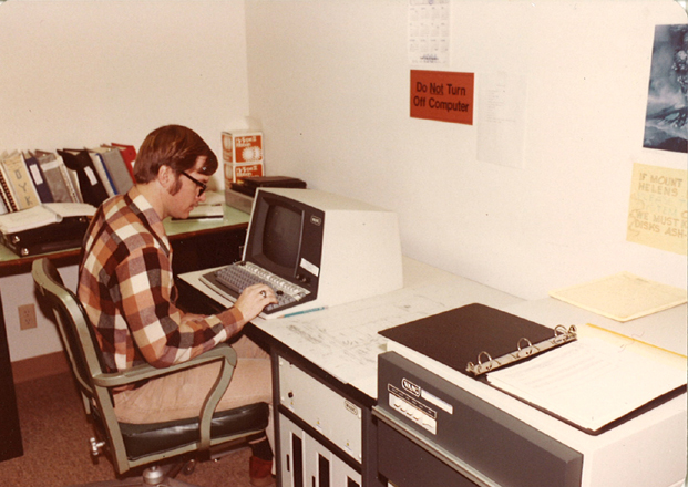
Of course, there have been the inevitable technological advances – extreme really, when you consider that all the work was done by hand in the early 1950s, and today, work is reliant on global positioning satellites, computers with vast untapped capabilities, and all things digital…even virtual. Engineers and surveyors alike relied on extensive mathematical calculations that were performed first with slide rules and trig tables, then with mechanical calculators, then with electronic calculators, and finally with computers and specialized software. Drawings were all hand drafted with pencil on velum or ink on Mylar; survey traced on the back of the sheet with the engineering design on the front (so the engineers could erase their mistakes without damaging the survey drawing). Now drawings are digital and can be revised, added to, spliced, trimmed, clipped, rotated, mirrored, or separated into layers to allow the “turning off” of specific features such as water systems, sewer systems, contours, or whatever the need may be. This has made it much easier to combine and share information, maps, and designs among engineers, surveyors, contractors, and clients.
Surveyors’ measuring tools evolved from transits, chains, levels, and level rods to robotic instruments that turn the angle, measure the distance, measure the elevation, calculate three dimensional coordinates, and digitally store the information while the one man crew walks about the site with a magic staff selecting points and features to locate, or he may get the three dimensional coordinate location directly from a satellite. The data can be downloaded to the office computer, spruced up, and a digital copy provided to the engineer within one day.
What Tomorrow Brings
We have no doubt that there will be more technological changes – it is inevitable. We also have to recognize that we live in a finite space (until designing for atmospheres beyond Earth’s becomes a standard practice but, let’s leave that for a future blog entry ) and site development and survey practices must adapt to more constricted sites. Water resources will continue to effect design as well as stormwater management and other environmental factors. Low-impact development and sustainable practices are here to stay and are required in many jurisdictions. Civil engineering and surveying will continue to work hand-in-hand as they have for generations, and we look forward to celebrating our 100th anniversary as we face new challenges alongside our clients in the next 40 years.