
In an ideal world, every underground utility is accurately identified, located, and mapped before project design and construction. The reality is that this approach can be costly, and sometimes the site conditions aren’t suitable even without budget constraints. Unless absolutely necessary, identifying and mapping every underground utility accurately prior to project design and construction is not typically done, although it is possible with today’s technology. Most of the time, reasonable efforts are made to locate and map underground utilities for a project with a common understanding that a few “surprises” will come up during construction. And they do.
Starting with the Surface
During the early phase of a project, such as site investigation, a topographic survey is normally performed to locate and map the existing site conditions, including both surface features and underground utilities. Underground utilities are located and marked with coded colors on the ground surface. The surveyors record utility locations and extents, adding this information to the topographic map, which will be used for the design base. Utility locating is usually provided by a service that identifies underground utility locations of water, natural gas, telephone and communication, and power. This information helps a surveyor estimate utility locations and connections. For gravity systems (sanitary sewer and storm drainage mains), which have more surface access such as manholes and catch basins, surveyors will locate these surface feature locations, record the inlet and outlet pipe location, measure the pipe sizes and invert elevations, and record the pipe materials. With these field measurements, observations, and record drawings, the surveyor can reasonably record the pipe connections and locations.
A topographic map developed by this traditional and “industry standard” method provides important information for a project design and construction, but it is far from worry-free. For instance, a water line location can be mapped, but its depth is still unknown; a storm drainage pipe between two manholes is normally presumed straight, but may not be. Contractors are normally required to perform their own utility locating before construction, but the same unknowns from the topographic survey exist.

Expect the Unexpected
A project designed by using a topographic map can have surprises come up during construction. For the Sid Snyder Way project at the Washington State Capitol Campus almost three years ago, a new PVC pipe was installed to replace an aged clay tile combined stormwater and sanitary sewer main between two manholes. The new pipeline was designed to run parallel to the existing one to be abandoned, and they were not supposed to cross each other. But during construction, undocumented clay tile pipes were found that crossed the proposed PVC main at the approximately same elevations at two locations. The usage and connections of these clay tile pipes were unknown. A video investigation revealed that the two clay tile pipes were actually connected and they were parts of the existing sewer main to be replaced. Instead of running straight between two manholes as the survey map depicted, the existing sewer main actually swung to pick up drainage from roadside catch basins and ran like an “S” between the two manholes. What a surprise.
Lessons from the Field
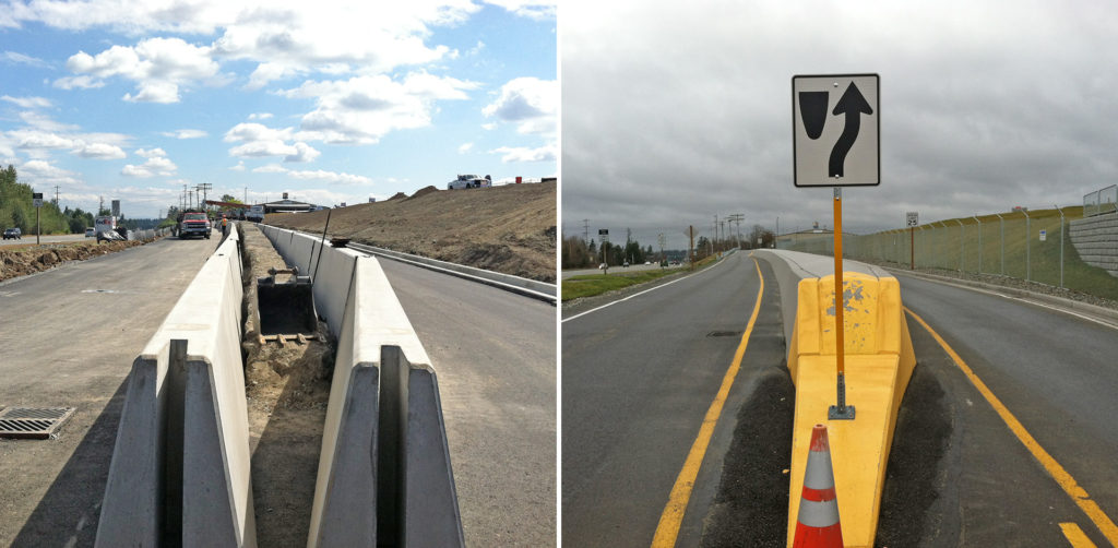
Knowing the exact location of a utility line still doesn’t mean worry-free. In the same Sid Snyder Way project, a mid-voltage power main was properly located and marked on the ground. But the contractor hit and broke the PVC conduit of the live power cables because the conduit was buried shallower than expected. Luckily no one was hurt. In another project at the Paine Field Airport, a roadway needed to be lowered to provide the required clearance for the safety of airplane approaches. A high voltage power line ran under the road. The project owner and the power company reported that the power main was deep. The adjacent electrical vault shows the power conduits were deep as well. To confirm the depth of the power line, two potholes were excavated near the lowest location of the proposed roadway and the potholes verified that the power line was deep. Everything seemed to be taken care of and there should have been no problems. But, by definition, a surprise is something not expected. During construction, the contractor found that the power main rose quickly just beyond the two potholes to an elevation near the proposed roadway surface. The only apparent option was to bury the power main deeper, because raising the road was not a choice. The cost would be huge, even if the power service interruption was not a problem. With creative thinking, the Reid Middleton team quickly came up with a solution: encasing the power conduits in concrete and making the concrete wall as the road divider. The problem was solved, but not because of the investigation prior to the construction.
Unforeseen soil and utility conditions nearly always come up. For designers, planning for revisions in design is important. For project owners, allocating some project budget for change orders is necessary. For contractors, dig carefully.