
In 1968, when I began my career in surveying, there had been little significant changes in the equipment and methods used since George Washington and Abe Lincoln were surveyors. We relied upon optical instruments (transits mostly) and steel tapes to measure and locate objects. Not much had changed since the 1800s, except the precision of our instruments and the lengths of the steel tapes we used.
Slide Rules & Trig Tables
We were just entering the electronic age where distances could be measured with expensive, extremely heavy and complex instruments that only government agencies could afford; they weren’t available to most local survey practitioners. Field calculations were completed using trigonometry tables and slide rules. The whole crew sat down to figure a slope distance, and if everyone didn’t get the same answer, you did it again until everyone arrived at the same conclusion. Speaking of field crews, when I started surveying, I was the rear-chainman on a four-person field crew. We also had a head-chainman, instrument operator, and a party chief. Chainmen were not allowed to touch the instrument, and my professor at the University of Washington (UW) said if you fell carrying the transit, you had to cushion it with your body to prevent damaging the instrument. Surveying used to be a labor intensive profession. Today, field crews are usually two person and increasingly one person with a robotic instrument or GPS unit. Times sure have changed!
Up in the Air
Aerial photogrammetry, which has been around since about 1900, was the preferred method of providing mapping for large scale projects. It relied upon surveying horizontal and vertical control points around the project site, photography from fixed wing aircraft, and stereoplotters to prepare basemaps. Today, aerial mapping firms seem to be going extinct as unmanned aerial vehicles (UAVs) and electronic processing by individual survey practitioners take their place. Several manufacturers offer small UAVs with three- to six-foot wingspans and a two- to 15-pound payload capacity that are approved for aerial mapping in many other countries. The FAA is currently seeking input from the U.S. survey community to develop regulations for their operation.
Innovation Combines Measuring Technologies in One
In the not too distant past, the steps to perform a “standard” topographic survey project were pretty much as follows:
- Research and locate horizontal control monuments (or markers) and benchmarks near the project.
- Establish secondary horizontal and vertical control from the control monuments to the project site.
- Perform an optical topographic survey of the site with an instrument operator and rodman.
- The project surveyor would then check the field notes and reduce the data in the office the next day and;
- Prepare the topographic basemap of the project incorporating any notes or field sketches in the mapping.
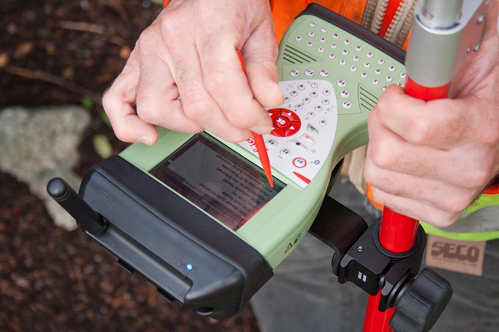
Reid Middleton has recently acquired a Leica MS50 MultiStation, which significantly improves the workflow that we are accustomed to. The new instrument is a highly accurate, 1-second theodolite with laser scanning and reflectorless capabilities (that is, it provides three dimensional position of almost any surface feature visible without needing a reflector placed to bounce the light back), two 5-megapixel cameras and standard distance measuring capabilities built-in. Paired with a Global Navigation Survey System (GNSS), direct geo-referencing is achieved without the need to sight known control monuments (that is, use an established marker to reference your position).
All of the project work described above can now be completed by a one-person field crew (if safety permits) improving efficiency and greatly streamlining the survey and mapping process. The on-board camera allows the field surveyor to view exactly what the instrument sees on his video screen and check the map he is creating as he walks the site collecting the appropriate survey and mapping points without having to be “behind the gun.”
The workflow using the MultiStation is:
- Occupy unknown position and determine state plane coordinates and elevation on site using the GNSS receiver.
- Perform optical, GNSS, laser scan or reflectorless topographic survey of the site complete with through the lens or project overview photographs. Review preliminary mapping in field survey controller; add hand drawn sketches directly into the survey controller.
- Download the data, photographs, sketches and preliminary mapping for the project surveyor to prepare the project basemap.
Reid Middleton believes this ‘next generation’ of innovative survey instrument will provide our clients and projects with increased efficiency and capabilities, resulting in better decisions with richer more detailed survey data and mapping products.
To see this new technology in action, please watch the video below.
 About Our Author: A lifelong practitioner in the Northwest, Mike heads up Reid Middleton’s survey team, supporting a wide range of public and private clients. His broad array of programmatic studies includes transportation and utility corridors, city-wide control networks and GIS inventories.